verified
Engineering Grade Accuracy
Look up any Florida parcel, pull the septic history, and draw your site plan — all in one place.
The mapping platform built specifically for Florida septic contractors and environmental engineers.
The mapping platform built specifically for Florida septic contractors and environmental engineers.
Deep property data including ownership, acreage, zoning, and legal descriptions directly from county records.
Historic site plans and permit data integrated directly onto the map for rapid site assessment.
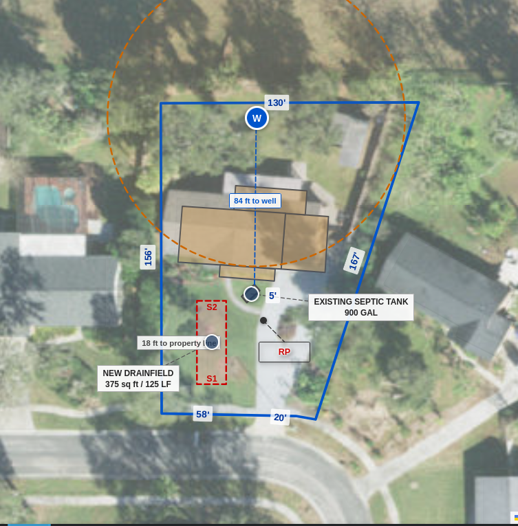
Wells have buffers automatically added based on system age. Setbacks to property lines and wells are automatically calculated—just move the system component to see real-time distance updates.
Drainfields and tanks are sized automatically based on house year and size. Everything is fully editable to match on-the-ground observations. Includes lookup for approved NSF-245 tanks.
Generate repair permits fast and painlessly with pre-filled technical data directly from the mapping database.
Use Wolfram Maps on Android and iPhone. Share site plans instantly with your crew or clients via text message or email from the field.
Stop switching between the county website, Google Maps, and your old permit binder. Wolfram Maps brings every Florida parcel and septic permit into one fast, reliable map designed for the field.
Perfect for individual installers and site surveyors.
Perfect for crews: share parcel research, site plans, and permit history across your entire office and field team.
Payments are processed securely by Stripe — a $160 billion PCI-compliant platform trusted by Amazon, Google, and Shopify. Your card information is never stored on our servers.
Export your designs in high-fidelity SVG format. Unlike static PDFs or raster images, our SVG exports maintain layered precision, allowing you to import them directly into CAD software or scaling for print without losing quality. Perfect for professional permit submittals.
"Saved me an hour per job. No more jumping between eBridge, the property appraiser site, and old permit binders—it's all in one stop."
Parcel search and property data is available for all 67 Florida counties. Septic permit history and eBridge document links are currently available in: Hernando, Hillsborough, Okeechobee, St. Lucie — with additional counties being added.
Parcel data is sourced directly from each county's Property Appraiser. Septic permit history comes from the Florida DEP OSTDS database. Soils data is from the USDA NRCS SSURGO survey. Well locations are from the Florida Department of Health.
Basic parcel lookup is available without a subscription. Pro features — including septic permit history, soil data overlays, and the siteplan editor — require a subscription. County agency and PPI accounts are managed separately; contact us for pricing.
Click Contractor Login to create an account. You'll need a valid Florida contractor license number during signup. Subscriptions are billed annually. For agency or PPI access, email info@wolframmaps.com.
Hillsborough County Notice: DH4015 Septic Permit Application tools for parcels in Hillsborough County are unavailable due to requirements in Florida Statute 112.313. Users may review the statute for additional details.